Showing posts with label 11. DISTRICT RANGAMATI. Show all posts

Wednesday, November 30, 2011

BUDDHIST TEMPLE

Chingrong Buddhist Vihara
CHITTAGONG


Chingrong Buddhist Vihara is oldest temple established about 2 hundred years ago. This Temple is located at Shilchari, Kaptai, Rangamati. The abbot of this Vihar is belongs to the Marma community. About fifty-sixty monks Remain here regularly. The abbot can speak Bengali and Burmese both language. Majority of the monks of this Vihar/temple are from Marma people. It is a public survice temple. The monks take part in Dana, funeral and other religious function. Chingrong Buddhist Vihara is about 76 km far from Chittagong town.

RAJBON BIHAR

Rajbon Bihar
RANGAMATI

It is 1 km far from Moitri Vihar situated at Rangamati municipality. Rajbon Bihar is one of the lovely Buddhist temple of Bangladesh. It is Located at rangamati district. It is one of the well-known tourist place of Rangamati just few km. from the main bus terminal. You can hire a boat or a auto-rickswa to visit the Bihar. It is a Pindapata temple. About 50 to 70 monks reside here regularly. Visitor are requested to keep in mind thist it is a place of prayer, so do not do anything that hart any one by you.


You must have to enter that place with bare feet to respect their tradition. In rajbon Bihr, there are many monkey stay around the Place. You can give them some food/nuts. There is a 7 stored building and wit a name each floor represents a paradise. Entering into the main prayer area, There are some small buildings/prayer hall inside.


A musk of Buddha Prepared from bronze and kept with a wall for the tourist inside the Bihar. No matter from where you are looking at that musk, you'll feel that its looking at you. There is an eldest monk, named "Ven Sadhanananda Mahathero (Bana Bante)", who is around 94 years of old, and lots of Buddhist used to visit with tribute to get Please from him, and the god. From all directions it is a beautiful tourist spot. So you are welcome in this site to visit.


Monk : Ven Sadhanananda Mahathero (Bana Bante)
(Rajbon Bihar Rangamati, Bon Bihar, Buddhist Bihar)

Wednesday, November 2, 2011

SHUVOLONG WATERFALL, SHUBOLONG WATERFALL (JHORNA)

Shuvolong Waterfall
RANGAMATI


Shuvolong has a beautiful waterfall with the natural surroundings.The only available path to reach at the waterfall is through water, through the lake. People visit there by boat. It is a popular place with the tourists for the waterfall, high hills and the natuarl surrounding it offers.This waterfall is just before the Shubholong Bazaar. Means from the waterfall, it will take around 5 minutes to reach at bazaar.


During rainy season the current of the waterfall is strong. During winter the current may not be strong, but water flow is there. Now the authority has made some facilities for the visitors there.


NOTE:
If you plan to visit this waterfall, you can make a single day trip easily from Dhaka. At any weekend, or government holiday, you can come to visit this beauty. 

More Photo:Shuvolong Waterfall

UNKNOWN WATERFALL (SEASONAL)

Unknown Waterfall
 RANGAMATI


This fountain is situated right side of your hand just after the Shubolong waterfall, and before the Subolong Bazar. This is a seasonal waterfall, and you may not see this one during winter or dry season. This is another beautiful fountain from Bangladesh

DHUPCHHORI WATERFALL, DHUPCHHORI JHORNA

Dhupchhori Waterall
RANGAMATI


Dhupchhori waterfall is located at the left side of your hand when you are going towards the Shubolong Waterfall from Rangamati. It will be around 5-10 minutes before. At the left hand side of your hand. Everyday plenty of tourists used to visit this path for the Shubolong Waterfall, but most of them don't find this one. Main reason is they are not heard about this one. Though its at left side, but its behind the trees and a small narrow passage. That's why from boat, tts not visible to the tourist.


This is a seasonal waterfall, only available during Rainy Season. Unlike other seasonal waterfall, this one used to produce prominent amount of water.Its not available to dry season, so no tourist used to come here.Due to less tourist at the spot, you can easily feel the calm and peaceful environment

Tuesday, November 1, 2011

MIDINGACHHORI WATERFALL

Midingachhori Waterfall
RANGAMATI


Midingachhori Waterfall is live Waterfall, and used to produce water more or less throughout the year. 99% of the tourists don’t used to visit this place due to lack of security. The only available path to reach at the waterfall is through water.So if you want to visit this places you will need to hire an engine boat from "Rajbari Ghat".Midingachhori and shuvolong Waterfall path is same, that water way. Both side of the river has hills covered with solid rocks.


At Shublong bazaar, you have to stop your boat, and the Army will ask you about your voyage. Just a routine check.From that place. it took around 30 minutes to reach the Midingachhori School. Since no tourist here, you'll find almost no engine boat around. All are rowing boats, which are very fast. Tribal people are moving one place to another using those boats.


Midingachhori Waterfall is just behind the school and you'll find the waterfall if you go further through the canal. From the main lake, there is a small canal about 50 meter will take you inside. This is not visible from the lake. Or you can ask the people around it. And you can reach the base where the stream of the water is dropping at the lake water by using your boat . Its a bit hard to reach at the bottom of the waterfall.
Its amazing, cause no torust, no chaos, only the dropping of the water. This is producing small amount of water, but through out the year it used to produce water like that.Its a live waterfall, and it never dry up(according to local).

NOTE: it looks  most beautiful during Rainy season. So You should must visit this Midingachhori Waterfall

RAIKHONG LAKE

Raikhong Lake
RANGAMATI


This lake is situated at the Rangamati district, not at Bandarban. But, for its location, you have to go there through the Bandarban. I believe that will be the easiest way among all other available, because Rangamati offers communication throw water path only, and also the lake is at the last corner of Rangamati district. No matter how you are going, I'll recommend you to pick an expert or guide with you.


Around the lake, you'll find two villages, one is at the eastern bank of the lake, and other one is at western bank. Those villages are known as PukurPara. May be its because of having around the lake. Both the village denizens are Tripura, but religiously Christian. People from West side of the lake used to do uphill and downhill task to come at the lake, but at eastern side's villagers can access the lake easily being so close of it, and having almost at flatland.


People also call this lake as PukurPara lake. Also few local people  pronouncing the lake's name as Raichong. Not sure which one will be the correct one. No matter what they are saying, or what we are, the beauty of the lake is not going to decrease by that.Local people used to catch fish from the lake. There is no prohibition about catching fish from that giant lake. Tilapia(তেলাপিয়া) is the first choice from those fishes to stuck over the net of the fishermen.


At the eastern corner of the lake, there is a tiny Jhiri generated from the lake water. probably that was created to keep the level of the lake water under control. During the rainy season the abundant water from the lake used to pass through that channel and used to join with the Raikhong Canal.Being many hills around the lake, and the mysterious behavior from the sky, you'll find different colorful scene at the lake water.

PUKURPARA WATERFALL, PUKURPARA JHORNA

Pukurpara jhorna
RANGAMATI

This country has several waterfalls scattered all around.PukurparaWaterfall is just one from that list.The waterfall that I'm going to introduce with you is a bit different than those. Interestingly the waterfall is located at the Bilaichhori Thana of Rangamati district. But to have an access to the waterfall, you need to use the trekking routes from Bandarban. It is just few hundreds meter apart from the Bandarban district's border. This waterfall is currently the widest waterfall from Bangladesh. It has a width of approximately 80 meters and the height of 4-6 feet on an average. During the rainy season, you will not be able to see any stones from the waterfall. Only visible are the cascades of water. Some people used to call this as the "Niagara of Bangladesh". 


After the waterfall, it as possibly a several hundred feet of down stream over solid rock(almost like a road of concretes), and over that rock, water from the fall is flowing downwards with a huge force. If you walk normally beside the stream, it will possibly take 40-50 minutes to reach at the bottom of the waterfall stream. Except the rainy season, the path is in good condition. But during rainy season, you can only risk your life if you attempt to go down over those slippy path. This waterfall is created from the water of Raikhong Canal and the water finally goes to the great Kaptai Lake. 


Some people used to call this Raikhong River. According to the name of the Canal/River, some people used to call this waterfall as Raikhong Waterfall. For your information, it is called PukurPara Waterfall, because there is a village near the waterfall named Pukur Para. Trekkers used to make a shelter at Pukurpara village, and only visits the waterfall for few hours. 


But if you make your trip a bit wisely, you can set few tents around the waterfall during summer or winter for nighttime stay. There are numerous dry and clean places around the waterfall for your camping. But unfortunately almost no one used to do that. Just wonder how it will feel when you are sleeping beside a waterfall at night. Bonus when it will be a full moon, or a night full of starts at null moon. 

KARNAPHULI RIVER

Karnaphuli River
RANGAMATI

Karnafuli river at Rangamati

Karnafuli River  (also spelt Karnafuli) the largest and most important river in chittagong and the chittagong hill tracts,Karnaphuli is a 667 metres (2,188 ft) wide river in the south-eastern part of Bangladesh. Originating from the Lushai hills in Mizoram, India, it flows 270 km (170 mi) southwest through Chittagong Hill Tracts and Chittagong and then follows a zigzag course before it forms two other prominent loops, the Dhuliachhari and the kaptai.

Karnafuli river at Chittagong

The Rangamati and the Dhuliachhari loops are now under the reservoir of the Kaptai earth-filled dam. The hydroelectric dam is situated just before the entrance of the river into the Kaptai loop. After coming out from the Kaptai loop the river follows another stretch of tortuous course through the Sitapahar hill range and flows across the plain of Chittagong after emerging from the hills near Chandraghona. Therefore, the river drains into the bay of bengal cutting across several hill ranges, viz the Barkal, Gobamura, Chilardak, Sitapahar and Patiya of the Chittagong Hill Tracts and Chittagong.

 Kaptai Dam On Karnaphuli River

It has possibly maintained its older course keeping pace with the uplift of the hill ranges and can be classified as an antecedent river. The Karnafuli is narrow and straight from Prankiang to waggachhari along Kaptai-Chandraghona road. The straightness of the river is probably due to a fault, which controlled the channel from Prankiang to Wagga. The main tributaries of the Karnafuli are the kasalong, Chengi, halda and Dhurung on the right and the Subalong, Kaptai, Rinkeong and Thega on the left.Flowing to the west through rangunia upazila and then keeping raozan upazila on the north and boalkhali upazila on the south, it receives the waters of the Halda river at Kalurghat just above the railway bridge. It then turns south, receives the waters of the Boalkhali and other khals and turns west circling round the eastern and southern sides of Chittagong Town. From the extreme corner of the chittagong port to the west, it moves southwest to fall into the Bay of Bengal 16.89 km below. It is navigable throughout the year by sea-going vessels up to Chittagong Port and by large boats, shallow draughts and all sorts of freighters and launches up to Kaptai river in the Hill Tracts.

There is a legend about the naming of the Karnafuli river. It says an Arakanese princess who fell in love with a tribal prince of Chittagong was once enjoying a moonlit boatride on the river with the prince. While admiring the reflection of the moon dancing on the rippled water surface, the princess inclined slightly and a flower tucked in the hair over her ear by the prince suddenly fell into the river. The princess was grief-stricken at losing the flower, which she held very dear as a present from her charming prince. She immediately jumped into the river to retrieve the flower but could not. Instead she was carried away by the fast-flowing current and vanished in the river. The prince dived into the river to rescue the princess but in vain. Out of sorrow he drowned himself in the river to unite with the princess after death. This tragedy gave the river its name Karnafuli from the word 'karnaful' meaning 'flower adorning the ear'. The river is known to the Marma tribe as the Kynsa Khyong. 

Monday, October 31, 2011

RINKHYONG RIVER

Rinkhyong River
 RANGAMATI

Rinkhyong River satellite view

Rinkhyong River  a number of small streams originating from eastern hills of Mizoram (India) and meeting together at the uppermost part of the Rinkhyong reserves are known as Rinkhyong. The river makes a torturous journey through the deep reserve forests and falls into kaptai lake near Belaichhari (Rangamati) about 30 km above Rinkhyongmukh, its original place of confluence with the karnafuli. The river is flashy and is 77 km long. It is navigable up to Gobachharimukh during wet season and further above it is used only for floating timber and bamboo.

KAPTAI LAKE

Kaptai Lake
RANGAMATI


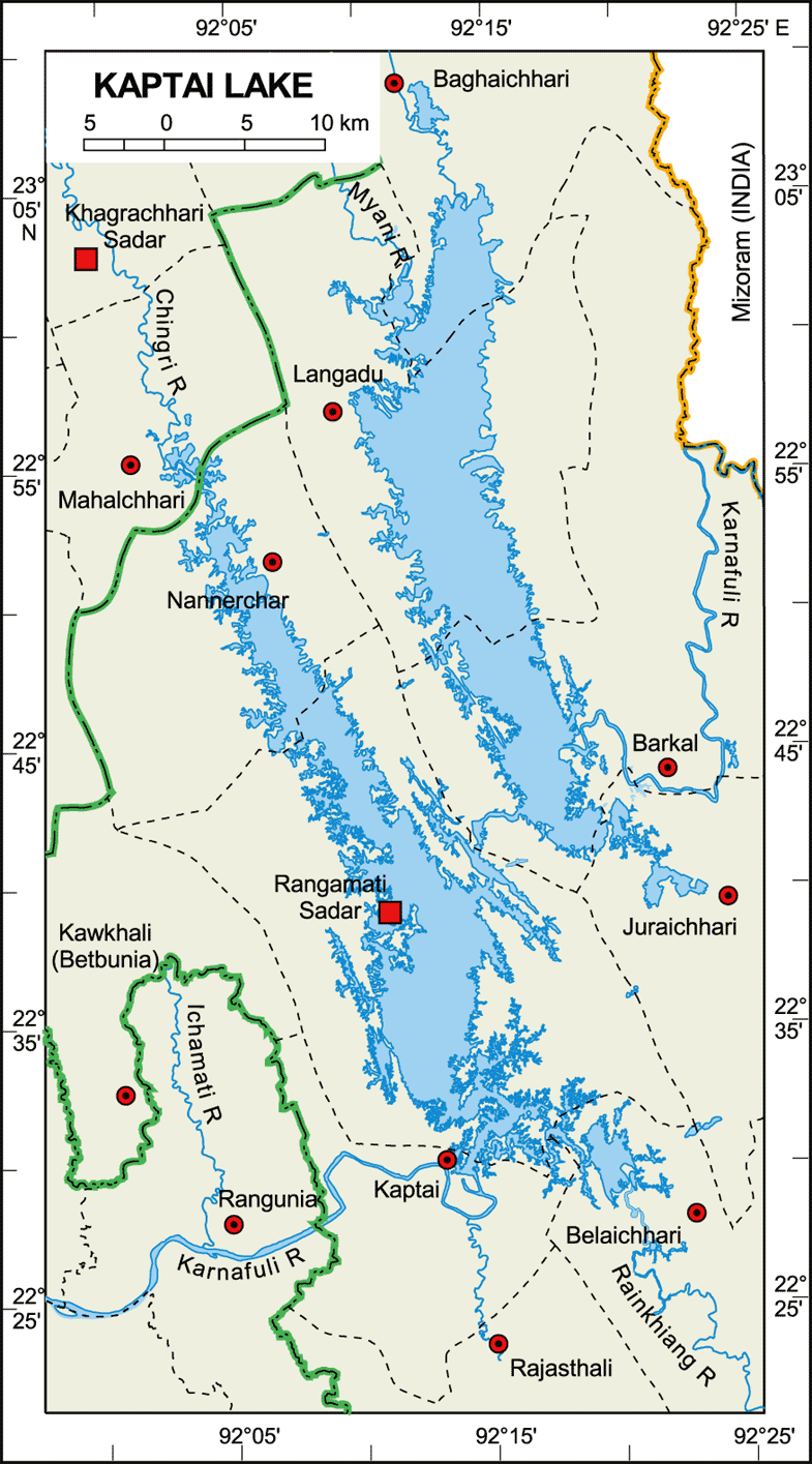
Kaptai Lake the largest man-made freshwater body in bangladesh. though created primarily for hydroelectric power generation, it contributes to produce significant quantity of freshwater fishes,navigation,flood control and agriculture. It is located in the Kaptai Upazila under Rangamat District of Chittagong Division. The lake was created as a result of building the Kaptai Dam on the Karnaphuli River, as part of the Karnaphuli Hydro-electric project. 

 Map of kaptai lake

The Kaptai Lake's average depth is 100 feet (30 m) and maximum depth is 495 feet (151 m). Its important morphometric and hydrographic features are as follows: surface elevation 31.1m, surface area 58,300 ha, volume 524,700 cu m, total annual discharge 1,707,000 cu m, storage ratio 0.31, mean annual water level fluctuation 8.14m, growing season 365 days, total dissolved solids 76 ppm and specific conductance 144 µmhos at 25ºC.

The scheduled passenger boat
The 'H'-shaped Kaptai Lake has two arms, joined by a narrow gorge near Shubalong, a part of the old Karnafuli river. Kasalong, the right arm of the lake, is fed by two streams, the Mayni and the kasalong, in the north and laterally by the Karnafuli. The left arm, Rangamati-Kaptai is fed by two streams, the Chengi in the north and the Rinkhyong in the south. The Karnafuli forms three prominent loops one at Rangamati, one at Dhuliachhari and the other at Kaptai. The Rangamati and the Dhuliachhari loops are now under the reservoir of the earth-filled dam. The Kaptai Lake has drowned almost the whole of the middle-Karnafuli valley and the lower reaches of the Chengi, Kasalong and Rinkhyong rivers.


Geologically, the lower part of Kaptai Lake, in and around the Kaptai-Rangamati region (ie Kaptai Syncline), is composed mainly of yellowish brown, fine to medium grained, massive to cross-bedded sandstone with alternating shale and silty shale (Tipam Sandstone Formation) and the upper part is featured by yellowish brown, fine to medium grained, subangular to sub-rounded, moderately to poorly sorted, massive to thick-bedded and occasionally cross-bedded sandstone with quartz granules, pebbles, clay galls and contains well preserved leaf impressions (Dupi Tila Formation).


However, around Shubalong and Barkal, the lake mainly comprises Bhuban formation. As the local people remove the protective vegetation around the lake, these rocks are exposed to the monsoon rains and thus eroded easily. This results in landslides, and the loose rock material is washed down the slopes and carried by rivers into the lake. As a result, the lake is silting up rapidly. By the early 1990s, in its 30-year existence, it had already lost about 25% of its volume due to siltation.


Apart from generation of hydroelectricity, the lake has become an important resource for some other considerations. It has created a diversified and long waterway. Many places that used to take a day or even more to reach have now become an hour's trip by speedboat or launch. It has become much easier to exploit forest resources that had earlier been inaccessible.

fishing

The whole lake is now a great tourist attraction. The lake's contribution to the development of agriculture and fishery is significant. Since the water level of the lake is maintained at different heights in different months of the year, the lakeshores are under an automatic irrigation system and are very fertile. People practice controlled farming in about 6,075 ha of land on leasehold basis through agreements with the local government.

carrying wood

DAM  Built in early sixties Kaptai Dam and the lake are the main attractions of Kaptai. If you are not visiting Kaptai separately then, don’t forget to go for a boating up to Kaptai on the Kaptai Lake while you go to Rangamati tour.

Kaptai dam

Sunday, October 30, 2011

KAPTAI NATIONAL PARK

Kaptai National ParK
RANGAMATI


The  Kaptai National Park is located in Rangamati Hill District over Karnaphuly and Kaptai Ranges under Chittagong Hill Tracts (South) Forest Division. It is accessible by air, road or train from Dhaka upto Chittagong then by road. Stablished in 1999
Kaptai National Park is exclusive for its huge plantations of 1873, 1878 and 1879, the preliminary act of modern forest management in this Indian sub-continent. At about 5464 hectors of land covered with the area of Kaptai National Park.


You can find plenty of old tree which were planted in 1873! This colossal plants and wild life of Kaptai National Park mystify the whole nature. There are a huge collection of plants in Kaptai National Park. You may feel a little bit nostalgic about your past in green village to the huge greenery of Kaptai National Park. In Kaptai National Park, there is a number of wild life like- Deer, elephant, Jungle cat, Monkey etc. Many species of Birds may also a matter of interest for the tourists and bird’s lovers. Kaptai National Park is a safe and sanctuary for birds and other wild life. Forest division founded picnic spot, restaurants in this Park. So, it will be a fascinating experience for you to visit Kaptai National Park.

 Wild Orchids of Kaptai National Park
Kaptai National Park is sited in Rangamati District over Karnaphuly and Kaptai Ranges under Chittagong Hill tracts (south), Forest Division. It is adjacent to Kaptai Bazar in the North- Eastern corner of Kaptai Upazela, Rangamati District.
The stifling rain forest on the bank of river Kornophuli is amazing in the Kaptai National Park. Kaptai Forest Rest House, Kaptai Mukh Forest Rest House, some picnic spots in the Kaptai National Park are other attractions of National Park. You can do boating, cruising, skiing, hiking in the Kaptai National Park.


Little wonder then that the Kaptai National Park is already amazingly popular with the locals. Some 50 000 people visit the park each year, paying an entrance fee of Tk10.00 per a person in support of this pleasurable wilderness. While most spend their time picnicking, others may go boating or speed boat cruising, water skiing or hiking. Great food can be found at a number of nearby restaurants for those looking for something a bit more substantial after a day spent in the great outdoors. The Kaptai National Park is relatively easy to reach.

THE HANGING BRIDGE, JHULONTO BRIDGE

The Hanging Bridge (Jhulonto Bridge)
RANGAMATI


Bangladesh Parjatan Corporation (BPC) built this Hanging Bridge over the Kaptai Lake which affords a convenient vantage point for taking in the beauty of the lake. This bridge is made during 1984 or around that time.It is the prime spot for tourists.


When you cross over the hanging bridge, definately feel the nature`s beauty. While crossing the bridge you could see the greenery of this place. This bridge leads to another hill over the canal close to the Parjatan motel. The man-made Kaptai lake, spreading over 680 km of crystal-clear water was formed by damming the Karnaphuli river, and has a picturesque hinterland of large hills and panoramic forests. A cruise on the calm waters of the lake can be a memorable experience.


Location: BPC, Rangamati, Chittagong, Bangladesh