
Source : Wikipedia
Division Of Bangladesh
Bangladesh is divided into seven major administrative regions called divisions (bangali: বিভাগ Bibhag). Each division is named after the major city within its jurisdiction that serves as the administrative capital of that division:
Barisal (বরিশাল Borishal)
Chittagong (চট্টগ্রাম Chôţţogram)
Dhaka (ঢাকা Đhaka)
Khulna (খুলনা Khulna)
Rajshahi (রাজশাহী Rajshahi)
Rangpur (রংপুর Rangpur)
Sylhet (সিলেট Sileţ)
Each division is further split into Districts (bangali: জেলা zila) which are then further sub-divided into Upazila .
DIVISION DESCRIPTION:
DHAKA:

Dhaka Division is an administrative division within Bangladesh. The capital and largest city is Dhaka. The division covers an area of 31,051 km², and has a population of 46,729,000 at the 2011 Census (preliminary results).
Dhaka Division is bounded by the Indian state of Meghalaya to the north, Barisal Division to the south, Chittagong Division on the south-east, Sylhet Division to the east, Rangpur Division to the north-west, and Rajshahi and Khulna Divisions to the west.
Dhaka Division, formerly Dacca Division of East Pakistan province, consists of one city corporation, 17 districts, 58 municipalities, 123 upazilas, 1,239 union parishads, 12,765 mouzas, 549 wards, 1,623 mahallas and 25,244 villages.
 (Lalbagh Fort,) constructed in the mid 17th century by Prince Mohammed Azam Shah, son of the Emperor Aurangzeb, and the Fort contains the tomb of Bibi Pari, daughter of Shaista Khan]
 (Lalbagh Fort,) constructed in the mid 17th century by Prince Mohammed Azam Shah, son of the Emperor Aurangzeb, and the Fort contains the tomb of Bibi Pari, daughter of Shaista Khan]
 .
|

Chittagong Division (Bengali: চট্টগ্রাম) is geographically the largest of the seven administrative divisions of Bangladesh. It covers the most south-eastern areas of the country, with a total area of 33,771.18 km² and a population at the 2011 Census (preliminary result) of 28,079,000.
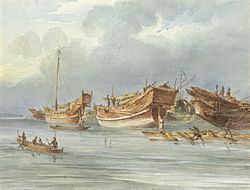
 Ships moored off Chittagong in the late 1820s.

The Division is subdivided into eleven districts (zilas) and thence into 99 sub-districts (upazilas). The first six districts listed below comprise the north-western portion (37.6%) of the Division, while the remaining five comprise the south-eastern portion (62.4%), the two portions being separated by the lower (or Bangladeshi) stretch of the Feni River; the upland districts of Khagrachhari, Rangamati and Bandarban together comprise that area previously known as the Chittagong Hill .
The Literacy rate is 22.08%.

Court building
The Literacy rate is 22.08%.

RAJSHAHI:

Rajshahi Division (Bengali: রাজশাহী বিভাগ) is one of the seven administrative divisions of Bangladesh. It has an area of 18,174.4 km² and a population at the 2011 Census of 18,329,000 (preliminary figures). Rajshahi Division consists of 8 districts (Bogra, Joypurhat, Naogaon, Natore, Nawabganj, Pabna, Rajshahi, Sirajganj), 70 Upazilas (the next lower administrative tier) and 1,092 Unions (the lowest administrative tier). This division is characterized by its cheap labour force. It has an excellent rail and road communication infrastructure. The divisional capital of Rajshahi is only four hours road journey away from Dhaka, the capital city.
Until 2010 this Division comprised 16 districts, but early in that year it was divided into two, when a new Division (Rangpur Division) was formed out of the 8 northerly districts that until then had been part of Rajshahi Division. Rajshahi was dominated by various Rajas, Maharajas and Zamindars.
Location:
Rajshahi division is in the mid western corner of Bangladesh. The famous river Padma borders Rajshahi division on the south and another famous river, Jamuna, lies across the eastern border. In the West, Rajshahi division shares a border with India.
Major places:
The major cities of Rajshahi division are Rajshahi, Bogra and Pabna. Rajshahi has an airport, with daily flights to Dhaka; however at present the government has suspended the air service between Rajshahi and Dhaka.

Chalan Beel as seen from the highway besides.

Education:
The major educational institute in Rajshahi are University of Rajshahi (RU), Rajshahi University of Engineering and Technology (RUET), Rajshahi Medical College (RMC), Shaheed Ziaur Rahman Medical College,Bogra. Rajshahi College, Azizul Haq College, Bogra. Edward College,Pabna.(Under National University), Pabna University of Science and Technology. University of Rajshahi (Estd.1953) is the second largest university of Bangladesh with around 50 disciplines and 6 institutes. RUET is only engineering institute in northern part of Bangladesh. It was founded in 1964 as a faculty of Engineering under the University of Rajshahi providing four year bachelor degree in Civil, Electrical & Electronics and Mechanical Engineering. In July 1986, it was converted into an institution named Bangladesh Institute of Technology, Rajshahi (BITR). Finally, parliament passed the University bill that ultimately paved the way to commence the activities of Rajshahi University of Engineering and Technology (RUET). Department of Computer Science and Engineering first introduced in 1998. Department of Electronics and Telecommunication Engineering and Industrial and Production Engineering was introduced in 2005.
SYLHET:

Sylhet Division (Bengali: সিলেট বিভাগ, pronounced Sileṭ Bibhag), also known as Greater Sylhet or Sylhet region, is the northeastern division of Bangladesh, named after its main city, Sylhet. It is bounded by Meghalaya State of India on the north, Tripura State on the south, Assam State of India on the east and Dhaka division on the west and Chittagong division on the southwest.
One of the most picturesque and archeologically rich regions in South Asia, is the Sylhet Division. Its bourgeoning economy has become a part of the attractions of the region, as landscapes are filled with fragrant orange and pineapple gardens and breathtaking tea plantations. Many Sylhet community members have found work and residence abroad, particularly in the United Kingdom and have been using remittances to fund projects and industries within the Sylhet Division, allowing the export industry and foreign investment sectors to grow.
Civil Administration:
In 1995, Sylhet was declared the 6th division of the country. Prior to that it was part of the Chittagong Division. The Sylhet Division is subdivided into four districts (zillah): Habiganj, Maulvibazar, Sunamganj and Sylhet. Further, the Sylhet Division contains 35 sub-districts (upazila/thana), 323 union parishad, 10,185 villages and 14 municipalities. Population: approximately 10 million, which is less than 7% of the total population of Bangladesh.
 Clockwise from bottom right- Jaflong Highway, Sripur, Jaflong, Srimangal, The Kean Bridge and Ali Amjad Clock Tower, Madhabkunda waterfall

History:
The 14th century marked the beginning of Islamic influence in Sylhet. A Muslim saint, Hazrat Shaikh al Mushaek Jalal Uddin, popularly known as Shah Jalal, arrived in Sylhet in 1303 CE from Mecca via Delhi with 360 Sufi saints and army generals such as Sikander Ghazi, Syed Nasiruddin and Khwaja Burhanuddin Qahtan defeating Govinda of Gaur. Sikander Ghazi was the direct nephew of Sultan Feroze Shah of Delhi. Under the spiritual leadership of Hazrat Shah Jalal and his 360 companions the local Hindus were brought under control and they began to spread Islam. He died in Sylhet in or around the year 1350 CE. His shrine is located inside the parameter of the mosque complex known as Dargah-e-Shah Jalal. Even today Shah Jalal remains revered; visitors arrive from all over Bangladesh and beyond to pay homage.. Saint Shah Jalal and his companions were responsible for the conversion of most of the populace from their earlier beliefs in Hinduism, Buddhism and Paganism to Islam. Shortly, thereafter, Sylhet became a centre of Islam in Bengal. In the official documents and historical papers, Sylhet was often referred to as Jalalabad during the era of the Muslim rule.
In the late 18th century, the British East India Company became interested in Sylhet and saw it as an area of strategic importance in the war against Burma. Sylhet gradually was absorbed into British control and administration and was governed as a part of Bengal. After the British administrative reorganization of India, Sylhet was eventually incorporated into Assam. It remained a part of Assam for the rest of the era of British rule. In 1947, following a referendum, almost all of erstwhile Sylhet became a part of East Pakistan, barring the Karimganj subdivision which was incorporated into the new Indian state of Assam. The referendum was held on 3 July 1947, there were a total of 546,815 votes cast on 239 polling stations, a majority of 43.8 per cent voted in favour of East Bengal. There were protests regarding bogus votes. However, the referendum was acknowledged by Article 3 of the India Independence Act of 18 July 1947. In 1971, Sylhet became part of the newly formed independent country of Bangladesh.
The Sylhet region has a "friendship link" with the city of St Albans, in the United Kingdom. The link was established in 1988 when the District council supported a housing project in Sylhet as part of the International Year of Shelter for the Homeless. Sylhet was chosen because it is the area of origin for the largest ethnic minority group in St Albans.
According to the St. Albans District Council: The majority of British Bangladeshis are of Sylheti ethnic origin (see British Bangladeshi). It is a testiment of Sylhet in its history of trade relations with other parts of the world. "Sylhet" is thought to be a misnomer of Syria, from the time Syrians and Arabs were among the merchant peoples of the Bengal delta, as well some historical cultural ties to China and Southeast Asia can be evident.
Culture:
Sylheti attachment to their regional identity also continues in the efforts of many Sylhetis to keep marital relationships within the same regional, cultural, social and religious background. Sylheti people are considered as a distinct ethnic group in Bangladesh; They are also generally more family orientated, follow and support Sylheti community culture, and are more conformist Muslims. These tendencies have led to some rivalry between non-Sylhetis and Sylhetis, due to differences of customs.
Marriages are practiced in a traditional Muslim style, with henna ritual (mehendi), and prayers. Sylheti marriages often include contracts of marriage outlining both the rights and obligations of both partners. Marriages in Sylhet often take place with partners in the United Kingdom and the US.
Given its unique cultural and economic development, and linguistic differences (Greater Sylhet region was a part of Assam and Surma Valley State for about 100 years during the British Raj in comparison to the rest of Bangladesh), and given that Sylhet has, for much of its recent history, been a region of a larger entity. As so many Sylhetis are resident abroad, Sylhet has a major flow of foreign currency from non-resident Bangladeshis.
Economy:
The area around Sylhet is a traditional tea growing area. The Surma Valley is covered with terraces of tea gardens and lush green tropical forests. Srimangal is known as the tea capital of Bangladesh and for miles around one can see the tea gardens on the hill slopes.
The area has over 150 tea gardens, including three of the largest tea gardens in the world both in terms of area and production. Nearly 300,000 workers, of which over 75% are women, are employed on the tea estates. Employers prefer to engage women for plucking tea leaves since they do a better job and are paid less than the men. Unfortunately recent drought has killed nearly a tenth of the tea shrubs.
The gardens are relics from the days of the British Raj. The plantations were started by the British and the managers still live in white timber homes as they did in those days. The bungalows stand on huge lawns and the service and lifestyle is pretty much unchanged.
A relatively new area that has come under tea cultivation is the sub-Himalayan terrain of Panchagarh. The soil and climate is highly favorable for growing tea here. In fact this area is contiguous with Assam and Bengal in India, where tea has been grown for decades. Beginning with only 300 acres (1.2 km2) of land in 2000, the cash crop is now being cultivated on over 3,500 acres (14 km2) in Tentulia, Sadar and Atoari upazilas of Panchagarh.
The humus content in the soil here is more than in the traditional tea-growing areas of Sylhet. The tea produced in Panchagarh is supposedly much better in quality than that of Sylhet. Several nurseries have been set up in Panchagarh and Thakurgaon to supply saplings to the tea gardens. Bangladesh exports tea to Pakistan and Russia.
There are large numbers of investments and businesses in the city and in large towns funded by Sylhetis living abroad, in particular by British Bangladeshis, over 95 percent of whom come from this Sylhet region. The Bangladesh government has set up a special Export Processing Zone (EPZ) in Sylhet, in order to attract foreign investors, mainly from the UK.

Shrine of Hazrat Shah Jalal Sylhet is a holy place for both Muslim and Hindus. It is a land of 360 awliyas. Notable Hindu saint Chaitanya Mahaprabhu visited his maternal and paternal family homes in Burunga (Balaganj),
The area around Sylhet is a traditional tea growing area. The Surma Valley is covered with terraces of tea gardens and lush green tropical forests. Srimangal is known as the tea capital of Bangladesh and for miles around one can see the tea gardens on the hill slopes.
The area has over 150 tea gardens, including three of the largest tea gardens in the world both in terms of area and production. Nearly 300,000 workers, of which over 75% are women, are employed on the tea estates. Employers prefer to engage women for plucking tea leaves since they do a better job and are paid less than the men. Unfortunately recent drought has killed nearly a tenth of the tea shrubs.
The gardens are relics from the days of the British Raj. The plantations were started by the British and the managers still live in white timber homes as they did in those days. The bungalows stand on huge lawns and the service and lifestyle is pretty much unchanged.
A relatively new area that has come under tea cultivation is the sub-Himalayan terrain of Panchagarh. The soil and climate is highly favorable for growing tea here. In fact this area is contiguous with Assam and Bengal in India, where tea has been grown for decades. Beginning with only 300 acres (1.2 km2) of land in 2000, the cash crop is now being cultivated on over 3,500 acres (14 km2) in Tentulia, Sadar and Atoari upazilas of Panchagarh.
The humus content in the soil here is more than in the traditional tea-growing areas of Sylhet. The tea produced in Panchagarh is supposedly much better in quality than that of Sylhet. Several nurseries have been set up in Panchagarh and Thakurgaon to supply saplings to the tea gardens. Bangladesh exports tea to Pakistan and Russia.
There are large numbers of investments and businesses in the city and in large towns funded by Sylhetis living abroad, in particular by British Bangladeshis, over 95 percent of whom come from this Sylhet region. The Bangladesh government has set up a special Export Processing Zone (EPZ) in Sylhet, in order to attract foreign investors, mainly from the UK.
Religion and Faith:

KHULNA:

Geography:

The Khulna division borders the Indian state of West Bengal to the west, the Rajshahi Division to the north, the Dhaka and Barisal Divisions to the east, and has a coastline on the Bay of Bengal to the south. It is part of the Ganges River delta or Greater Bengal Delta. Other rivers include the Madhumati River, the Bhairob River and the Kopotokkho River. The region also includes several islands in the Bay of Bengal .
Administrative Districts:
Khulna Division consists of the following ten Districts (zilas), subdivided into 59 sub-districts (upazilas):Economy:
Khulna was the backbone of the East Pakistan's main foreign currency earner Jute industry. There are many large Jute mills located in Khalishpur near Khulna city processing Jute fiber, besides the other heavy industries like Khulna News Print Mills and Khulna Hardboard Mills. The country's second seaport, Mongla Port, and the country's only ship building yard is located within Khulna division.
The largest mangrove forest in the world - the Sundarban - is spread over the three most southerly districts of Satkhira, Khulna and Bagherhat.
Education:
Universities: Khulna University, Khulna University of Engineering and Technology (KUET), Colleges: Khulna medical college, B.L College,Khulna Girls College . Khulna Public College, Majid Memorial City College, Khulna, M.A. Majid College, Dighalia, Khulna, MM College, Jessore, Shundorban College, Cantonment Public School and College, Jhenaidah Cadet College, Phultala M.M. College, Khan Jahan Ali Ideal College, Pioneer Govt Mohila College
Schools: Khulna Zilla School, Khulna Collegiate School, Coronation Govt. Girls School, Dighalia M.A. Majid Secondary School, Dighalia, Khulna, Fatima Girls High School Jessore Cantonment Public School, Rotary School, S.B.S.N, Damoder M.M. High School, Khulna Lions Schools, St. Joseph's High School, St. Jevier's School, Rev. Paul High School,
Other Educational Institutes: Besides, Khulna has six IGV (Integrated General and Vocational) schools and one technical school of UCEP (Underprivileged Children's Educational Programs), which is a non-profitable organization. Six IGV schools are: UCEP-K C C School, Rupsha UCEP-Sonadanga School, Sonadanga UCEP-M A Majid School, Fulbarigate UCEP-Khalishpur School, Khalishpur UCEP-Zohra Samad School, Tootpara UCEP-Wazed Ali School, Banorgati
and the technical school is: Khulna Mohsin Technical School, which is situated at 7, Junction Road , Baikali, Khulna.
BARISAL:

The Greater Barisal region (Barisal District along with five other neighbouring districts) was created Barisal Division on 1 January 1993
Administrative Districts:
The Division is subdivided into six districts (zilas) and thence into 39 sub-districts (upazilas). Lower level administrative areas are 353 union parishads, 3159 mouzas, 12 municipalities, 25 wards and 4163 villages..Tourism:
Durga Sagor is another beautiful Dighi where lot of guest birds comes in every winter season.
Economy:
Barisal was once known as "Crop house of Bengal" for her rich rice production. It is still an important rice producing area of the country. Since middle age Barisal acted as a trans-shipment center for rice, hides, and pulses for the Bengal. Bakery, textile, Pharmaceutical products are output of a few industrial installation. There is a medical college (Sher-e Bangla Medical College) affiliated with the National University. It also has a famous Cadet College - Barisal Cadet College (est. 1985) which has a number of record results on both HSC and SSC board exams. The present divisional commissioner of Barisal Division is Mr. Mohammad Haroon Chowdhury.
Education:

Barisal division has one of the highest literacy rates of the country just behind Dhaka division. One of the country's oldest educational institution, Brojomohun College was established in 1889. Sher e Bangla Medical College and one science and technological university is also built. Recently the government has passed a bill approving building of a new Barisal University.
Transportation:
Numerous numbers of rivers and canals enforce the inhabitants to use boat as the main medium of transportation. Main rivers are Arial Khan, Bishkhali, Burishwar, Tentulia, Paira, Haringhata, Baleshwar, Kirtankhola, Katcha, Agunmukha. It is linked by steamer with Dhaka (73 miles [117 km] north) and with Chittagong to the southeast. Road communication has improved significantly over last decades with building many bridges. The Barisal Airport has regular flight service to Dhaka
Religion:
The religions in Barisal Division is Muslim, Hindu, Christianity and Buddhism
RANGPUR:

Rangpur Division (Bengali: রংপুর বিভাগ) became Bangladesh's seventh division on January 25, 2010. Before that, it had been the northern 8 districts of the Rajshahi Division. The Rangpur division consists of eight districts: Rangpur, Dinajpur, Kurigram, Gaibandha, Nilphamari, Panchagarh, Thakurgaon, and Lalmonirhat. There are 58 Upazillas or subdistrics under these eight districts. Rangpur is the northernmost division of Bangladesh and has a population of 15,665,000 at the 2011 Census.
The major cities of this new division are Rangpur and Dinajpur. Rangpur has well-known educational institutions, such as Carmichael College, Hajee Mohammad Danesh Science and Technology University, Rangpur Medical College, Rangpur Cadet College, and Begum Rokeya University.The central City - Rangpur - has a historical importance and indentity. Mansingh, commander of Emperor Akbar, conquered part of Rangpur in 1575. Rangpur came completely under the Mughal empire in 1686. Mughalbasa and Mughalhat of Kurigram district still bear marks of the Mughal rule in the region. During the Mughal rule Rangpur was under the sarker of Ghoraghat. Rangapur Ghoraghat has been mentioned in the Riyaz-us-Salatin. During the early period of the company rule fakir-sannyasi resistance and peasant rebellion were held in Rangpur.